Autodesk introduces new solutions for building information modeling

New versions of Revit, AutoCAD Civil 3D, and Autodesk NavisWorks help construction teams and engineers create better projects with innovative designs.

Publisher
Tisková zpráva
09.04.2008 23:50
Autodesk, s.r.o.

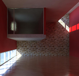
One of the innovations in the Revit 2009 platform is the proven powerful visualization tool mental ray®
Autodesk, a global leader in 2D and 3D design software for manufacturing, construction, media, and entertainment, announced at its regional press conference Autodesk World Press Days Europe 2008 new versions of software solutions for Building Information Modeling (BIM): Revit Architecture 2009, Revit Structure 2009, Revit MEP 2009, AutoCAD Civil 3D 2009, and Autodesk NavisWorks 2009. The term building information model refers to an integrated workflow based on coordinated, reliable project information at all stages of designing, constructing, and operating buildings. By deploying BIM solutions, architects, engineers, contractors, and investors can easily create coordinated digital design information and documentation, use this information to accurately predict performance, appearance, and costs, and reliably execute projects faster, more economically, and with a lower environmental impact.


“The demand for innovation and efficiency in building design, civil engineering, and construction drives the increasing adoption of BIM technologies in the construction industry,” says Jay Bhatt, senior vice president, Autodesk AEC Solutions. “Autodesk is continuously working to improve technologies that provide our customers with competitive advantages and design innovations. Our BIM solutions represent cohesive, efficient design and analytical tools and further advance the workflow revolution initiated by the Revit platform.”
Autodesk's 3D modeling technologies help customers understand and improve the performance and functioning of proposed buildings before they are constructed. Through widely recognized analytical technologies Robobat, Intelisolve, and NavisWorks – now part of Autodesk's portfolio – the 2009 generation BIM solutions assist architects, engineers, and designers in making better design decisions at earlier stages of the process. The enhanced BIM solutions also facilitate collaboration on projects and provide better integration among building design, civil engineering, and various construction professions.

Revit Platform

The Revit platform includes enhancements across all specialized solutions for architects and engineers. It keeps information coordinated, up-to-date, and accessible in an integrated digital environment, providing project teams with a clear overall overview of their designs and optimizing the decision-making process. Innovations in the Revit platform:

Revit Architecture 2009 (BIM for architects and designers) allows customers to capture initial design concepts with improved analytical and visualization features through:
  • enhanced features for sustainable design and energy analysis that enable easy data exchange with partner applications,
  • improved visualization functionality with the new Mental Ray rendering core, providing greater speed, quality, and usability.

Revit Structure 2009 (BIM for structural engineers, designers, and drafters) has been enhanced with better modeling and documentation features and is compatible with Robobat solutions, which Autodesk newly included in its portfolio following its acquisition. The AutoCAD Revit Structure Suite now includes the AutoCAD Structural Detailing application, which allows:
  • detailed drawings of steel and reinforced concrete structures and shop drawings,
  • the creation of top-notch formwork drawings.
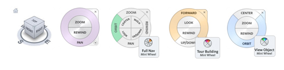
Autodesk 3dUI includes ViewCube™ and SteeringWheels™, two intuitive interactive navigation tools. Thus, it offers unification of the control of various Autodesk 3D products.


Revit MEP 2009 (Revit for building services design) provides customers with detailed, specific modeling features, such as:
  • air conditioning units, commercial compressors, rooftop air conditioning units, and high-efficiency water heat pumps.

Autodesk NavisWorks 2009

The Autodesk NavisWorks solution extends the value of BIM technologies by allowing the aggregation of construction information with data and geometry from other sources. By integrating building information, data, and geometry, Autodesk NavisWorks solutions achieve the best possible understanding of the entire project, even when various software platforms and applications are used. They contribute to better coordination, collaboration, and smooth execution of design and construction projects. With Autodesk NavisWorks solutions, users can:
  • aggregate design models and data from documents created in Autodesk applications as well as those from other vendors,
  • create more complex views of projects, analyze and simulate designs before construction begins,
  • make better design and construction decisions and enhance the value of investments in design software.

The Autodesk NavisWorks solutions consist of four software products: Autodesk NavisWorks Review is for basic model aggregation; Autodesk NavisWorks Simulate includes NavisWorks Review and adds timeline and 4D functionality; Autodesk NavisWorks Manage further adds clash detection features, allows seamless visualization of all types of models, accurately replicates designs, simulates 4D construction schedules, and detects clashes. This ensures that everyone involved in the project is working on the same digital page, whether creating, viewing, or assessing 3D models. Autodesk NavisWorks Freedom is a free viewer for Autodesk NavisWorks NWD and 3D DWFTM files.

AutoCAD Civil 3D 2009

AutoCAD Civil 3D 2009 brings the benefits of building information modeling to civil engineering, from surveying and design to documentation deliverables and 3D models for machine control during construction. The most important new features of AutoCAD Civil 3D 2009:
  • Comprehensive stormwater hydraulic and hydrology solutions for the design of storm drainage systems, watershed analysis, detention pond modeling, and culvert analysis.
  • Comprehensive surveying functionality that enables users to directly import raw data, refine measurement results, and create points, data, and surfaces that are directly integrated into the model to support the design process.
  • Road design based on criteria that ensure compliance with local design requirements such as stopping sight distance, sight distance, and light spacing.
  • Ability to easily implement solutions for sharing model data between project teams using standard AutoCAD external references and intelligent data shortcuts of Civil 3D (without the need to use Autodesk Vault).


About Autodesk
Autodesk is a global leader in 2D and 3D design software for manufacturing, construction, media, and entertainment. Since the introduction of AutoCAD in 1982, Autodesk has developed the broadest portfolio of leading digital prototyping solutions that help customers practically test ideas before they are realized. Fortune 1000 companies use Autodesk tools to visualize, simulate, and analyze the real-world performance of their designs in the early stages of development, helping them save time and money, improve quality, and foster innovation. For more information about Autodesk, visit www.autodesk.com or www.autodesk.cz.

The English translation is powered by AI tool. Switch to Czech to view the original text source.