Lead Dušan: studio Koucký-Lisecová
The summary output of our initial research, which is briefly described below, is the "New Atlas of the Czech Republic" as part of a globalized world. The individual maps illustrate the integration of the Czech territory into the global system of communication and exchange.
1/ thesis: what is a meta-city
Meta-city is a new urban reality. A city in the era of globalization and digitalization is defined more by the dynamics of virtual relationships than by the stability of its material structure. Its description requires units of time as much as units of space; newly created maps express not only physical distances, but also the time in which a destination can be reached; they display the structure of individual networks (infrastructure) and the coverage of the territory by various services, showing the distribution and density of productive human activities and their relationship
to residential areas. The basic measure of a city's "success" thus increasingly becomes its infrastructure. The historical structure of the city is becoming a commodity that can be sold in some way. In many cases, it simply becomes a "brand." Meta-city is a virtual layer of the city that lies "above" its material form. Any communication-connected point can become part of the meta-city - even a moving one (the interior of a means of transport). The contradiction between the local and the global ceases to exist. One flows freely into the other and vice versa. Globalization presupposes a complete detachment from the material world, says Saskia Sassen. The essence of infrastructure is invisible. What was once material is now being virtualized: not only do we pay with virtual money, but even real estate is becoming mobile as it transforms into information in the marketplace.
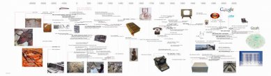
Meta-city is the city as an informational structure. The very idea of the meta-city is not completely new: the connections of places in space due to human activity have been occurring since the beginnings of human existence and are related to communication between people from smoke signals through messengers, pneumatic mail, and telegraph to telephone and internet, from footpaths through roads to highways, from vehicles through trains and cars to airplanes and beyond. Dematerialization brings hyper-mobility. Today's last vehicle is an image, wrote Paul Virilio. Information technology and telecommunications have dramatically changed the traffic in the city. Above all, they have accelerated all communication processes. The mobility of information in the virtual realm has paradoxically brought about the need for increased mobility in the material world because everything is happening faster, thus also intensifying the movement of things and people. The feedback loop of the virtual meta-city is the lively traffic of the real city. Meta-city is the strategy of tomorrow. Meta-city is a way to avoid mega-city. How to maintain the quality of life in a world that is evolving and changing. A mega-city is an extensively growing, thinning metropolis that digs deeper and deeper into the landscape, leaving nothing but a strange world that is neither a city nor open countryside. There is a process of peripheralization. What is emerging is called urban sprawl (in Czech, "sídelní kaše") and represents a mutilated parody of urban structure and landscape. The meta-city, an invisible virtual layer of vital relationships, gives humans the opportunity to avoid the stone mega-scale and instead move within a lively changing network. The meta-city offers a way to protect cultural landscapes and preserve historical heritage. It not only provides the possibility to complement the city and intensively define urbanized areas of the 19th and 20th centuries but also, by connecting other not too distant cities, expands the possibilities of wholes.
2/ zoom: region as meta-city
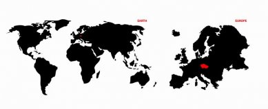
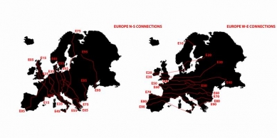
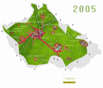
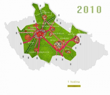
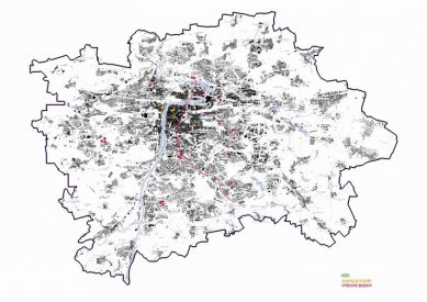
The new map of the Czech Republic is based on the aforementioned assumptions of the meta-city project (cz)4, which, based on an analysis of the current situation of the Czech Republic as a European region, suggests the possibility of understanding and transforming the territory of the Czech basin. It is a city with approximately 10 million inhabitants, which has three main centers (Prague, Brno, Ostrava) and another eleven smaller municipalities (today's regional cities). It is a city that competes for a significant place on the economic and cultural map, not only of Europe but also aims to rank among the metropolises of the world as a "global city" in the cultural landscape. We have attempted to define the territory of the Czech Republic as a dynamic virtual structure, and for its description, we have used units of time instead of distances. Alongside the traditional metric of distance, we implemented a temporal metric, related to the currently most commonly used means of transporting people and goods - an hour's drive by car. Thus, a new map of the Czech Republic emerged, which is gradually being shape deformed according to infrastructure quality compared to traditional cartographic representation. Such a map may be "virtual," but from a practical standpoint, it has significant informative value. It states not only the real distance between individual points in time but also highlights areas that are more or less "connected to the system." Other supplementary maps display the structure of telecommunications networks, radio and television coverage, their relationship to residential areas, but also to areas that appear "empty" at first glance. They therefore indicate the reach of immediate connection, which nullifies physical distance.
3/ detail
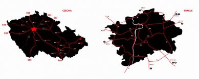
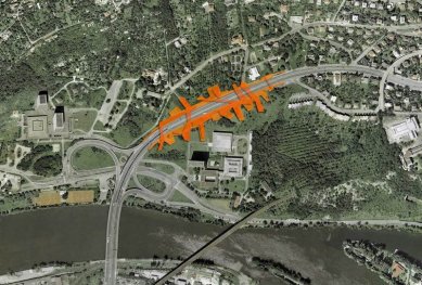
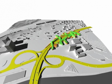
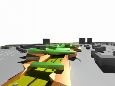
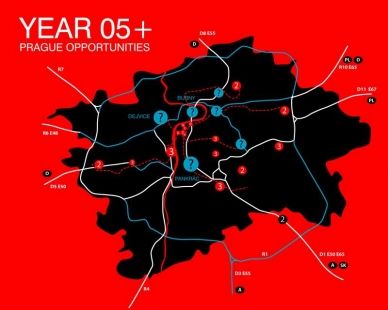
The main class of meta-city (cz)4: Searching for the potential of the north-south corridor: Several European road routes pass through Prague: E50, E55, E65, as well as E48 and E67. The north-south corridor runs in its entirety from Prosek to Jižní město via route E55, while the others somehow "touch" it. Given the numerical designation and the total number of these routes (the main ones are E10-E90 in the direction of parallels and E05-E95 in the direction of meridians), it can be stated that this is a location in Europe at the center. However, the center of Europe is now clearly in Brussels. And because in the meta-city being physically in the middle does not have to mean being meaningfully in the middle, it is necessary to attempt to "at least slightly displace" the center. We should therefore strive to give physical centrality in Europe the long-suppressed significance it deserves. We should seek its potential also because the north-south corridor does not enjoy an unequivocally good reputation. A significant body of critics points out that it has distorted the center of Prague, splitting it in two. It intruded as a non-place into the city and made life in it impossible. We want to try a positive approach and see whether it is possible to make
the corridor not only part of the city but its main street for the twenty-first century. We propose ways to maintain the significance of this busy European roadway without diminishing the city's viability. We suggest new elements of the city, integrated into a much broader context than their immediate physical surroundings. We propose a new perspective.
Our thanks go to:
PhDr. Jana Tichá - helped with the theoretical definition of the term,
Doc. Ing. arch. Radek Kolařík
students of VŠUP A2, co-submitters of the proposals for the Czech and Slovak pavilions for the X. Architecture exhibition in Venice.
Roman Koucký, Radek Kolařík, and Jana Tichá, Prague, 2005-11-30
1/ thesis: what is a meta-city
Meta-city is a new urban reality. A city in the era of globalization and digitalization is defined more by the dynamics of virtual relationships than by the stability of its material structure. Its description requires units of time as much as units of space; newly created maps express not only physical distances, but also the time in which a destination can be reached; they display the structure of individual networks (infrastructure) and the coverage of the territory by various services, showing the distribution and density of productive human activities and their relationship
to residential areas. The basic measure of a city's "success" thus increasingly becomes its infrastructure. The historical structure of the city is becoming a commodity that can be sold in some way. In many cases, it simply becomes a "brand." Meta-city is a virtual layer of the city that lies "above" its material form. Any communication-connected point can become part of the meta-city - even a moving one (the interior of a means of transport). The contradiction between the local and the global ceases to exist. One flows freely into the other and vice versa. Globalization presupposes a complete detachment from the material world, says Saskia Sassen. The essence of infrastructure is invisible. What was once material is now being virtualized: not only do we pay with virtual money, but even real estate is becoming mobile as it transforms into information in the marketplace.
Meta-city is the city as an informational structure. The very idea of the meta-city is not completely new: the connections of places in space due to human activity have been occurring since the beginnings of human existence and are related to communication between people from smoke signals through messengers, pneumatic mail, and telegraph to telephone and internet, from footpaths through roads to highways, from vehicles through trains and cars to airplanes and beyond. Dematerialization brings hyper-mobility. Today's last vehicle is an image, wrote Paul Virilio. Information technology and telecommunications have dramatically changed the traffic in the city. Above all, they have accelerated all communication processes. The mobility of information in the virtual realm has paradoxically brought about the need for increased mobility in the material world because everything is happening faster, thus also intensifying the movement of things and people. The feedback loop of the virtual meta-city is the lively traffic of the real city. Meta-city is the strategy of tomorrow. Meta-city is a way to avoid mega-city. How to maintain the quality of life in a world that is evolving and changing. A mega-city is an extensively growing, thinning metropolis that digs deeper and deeper into the landscape, leaving nothing but a strange world that is neither a city nor open countryside. There is a process of peripheralization. What is emerging is called urban sprawl (in Czech, "sídelní kaše") and represents a mutilated parody of urban structure and landscape. The meta-city, an invisible virtual layer of vital relationships, gives humans the opportunity to avoid the stone mega-scale and instead move within a lively changing network. The meta-city offers a way to protect cultural landscapes and preserve historical heritage. It not only provides the possibility to complement the city and intensively define urbanized areas of the 19th and 20th centuries but also, by connecting other not too distant cities, expands the possibilities of wholes.
2/ zoom: region as meta-city
The new map of the Czech Republic is based on the aforementioned assumptions of the meta-city project (cz)4, which, based on an analysis of the current situation of the Czech Republic as a European region, suggests the possibility of understanding and transforming the territory of the Czech basin. It is a city with approximately 10 million inhabitants, which has three main centers (Prague, Brno, Ostrava) and another eleven smaller municipalities (today's regional cities). It is a city that competes for a significant place on the economic and cultural map, not only of Europe but also aims to rank among the metropolises of the world as a "global city" in the cultural landscape. We have attempted to define the territory of the Czech Republic as a dynamic virtual structure, and for its description, we have used units of time instead of distances. Alongside the traditional metric of distance, we implemented a temporal metric, related to the currently most commonly used means of transporting people and goods - an hour's drive by car. Thus, a new map of the Czech Republic emerged, which is gradually being shape deformed according to infrastructure quality compared to traditional cartographic representation. Such a map may be "virtual," but from a practical standpoint, it has significant informative value. It states not only the real distance between individual points in time but also highlights areas that are more or less "connected to the system." Other supplementary maps display the structure of telecommunications networks, radio and television coverage, their relationship to residential areas, but also to areas that appear "empty" at first glance. They therefore indicate the reach of immediate connection, which nullifies physical distance.
3/ detail
The main class of meta-city (cz)4: Searching for the potential of the north-south corridor: Several European road routes pass through Prague: E50, E55, E65, as well as E48 and E67. The north-south corridor runs in its entirety from Prosek to Jižní město via route E55, while the others somehow "touch" it. Given the numerical designation and the total number of these routes (the main ones are E10-E90 in the direction of parallels and E05-E95 in the direction of meridians), it can be stated that this is a location in Europe at the center. However, the center of Europe is now clearly in Brussels. And because in the meta-city being physically in the middle does not have to mean being meaningfully in the middle, it is necessary to attempt to "at least slightly displace" the center. We should therefore strive to give physical centrality in Europe the long-suppressed significance it deserves. We should seek its potential also because the north-south corridor does not enjoy an unequivocally good reputation. A significant body of critics points out that it has distorted the center of Prague, splitting it in two. It intruded as a non-place into the city and made life in it impossible. We want to try a positive approach and see whether it is possible to make
the corridor not only part of the city but its main street for the twenty-first century. We propose ways to maintain the significance of this busy European roadway without diminishing the city's viability. We suggest new elements of the city, integrated into a much broader context than their immediate physical surroundings. We propose a new perspective.
Our thanks go to:
PhDr. Jana Tichá - helped with the theoretical definition of the term,
Doc. Ing. arch. Radek Kolařík
students of VŠUP A2, co-submitters of the proposals for the Czech and Slovak pavilions for the X. Architecture exhibition in Venice.
Roman Koucký, Radek Kolařík, and Jana Tichá, Prague, 2005-11-30
The English translation is powered by AI tool. Switch to Czech to view the original text source.


1 comment
add comment
Subject
Author
Date
This Is Really A Great Idea ...
Gerhard Hakamuruchi
16.03.06 11:01
show all comments